Hear from our satisfied clients: They praise our precision, timely delivery, and clear communication—reliable data, seamless deliverables, and proactive support that reduce risks and keep projects on track.
Precision Mapping for a Smart world enables accurate location insights, enhances decision-making, optimizes resources, and supports sustainable development by integrating advanced geospatial technologies with intelligent data analysis.
Charting our legacy reflects dedication and innovation, blending traditional surveying with advanced digital mapping, delivering thorough, dependable spatial data and supporting smart, sustainable development for generations through comprehensive geospatial excellence.
Ready for reliable topography solutions? We combine precision surveying, advanced mapping technology, and expert insights to deliver accurate terrain data, empowering smart planning, sustainable projects, and confident decision-making from the ground up.
Professional land surveying and cutting-edge mapping services merge accuracy, innovation, and expertise, delivering precise spatial data, supporting efficient planning, enabling smart infrastructure, and fostering sustainable growth for diverse industries and communities worldwide.
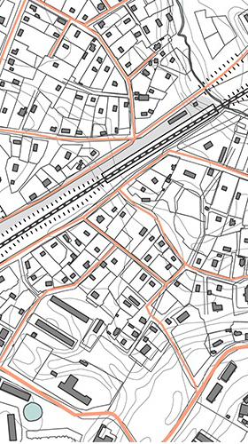
A topographic survey maps land features and elevations, providing precise spatial data for planning, construction, and sustainable development using advanced tools.
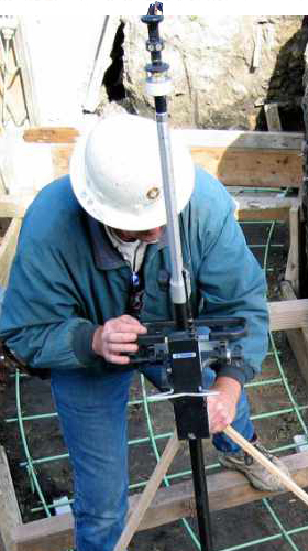
Construction staking marks precise building locations and elevations on-site from plans, ensuring accurate placement and guiding construction progress efficiently.
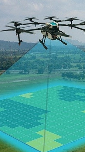
Drone surveys capture precise aerial data for mapping, enabling fast, accurate, and safe geospatial analysis for construction, land management, and planning.
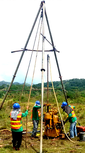
Soil testing analyzes soil nutrients and properties to optimize fertility and crop growth. The Safe Bearing Capacity (SBC) test determines soil’s load capacity for safe, stable construction foundations.

Let us know how to get back to you.
Experience Precision and Expertise in every step with Indrakshi Consultants. From boundary and cadastral surveys to drone mapping, topography, and geotechnical SBC testing, our rigorous methods, modern technology, and clear deliverables ensure reliable data, faster approvals, and confident decisions throughout your project lifecycle.
A successful survey starts with a clear understanding of objectives, constraints, and stakeholders. In the initial consultation, we review your project scope, land records, drawings, expected accuracy, deliverables, budget, and timelines. We identify regulatory requirements, coordinate systems, and permissions (including drone/UAS if needed), and align on communication, safety, and escalation protocols to reduce surprises later.
Before mobilization, we verify real-world site conditions to refine the plan. A reconnaissance visit checks access, terrain, vegetation, water bodies, hazards, utilities, security, and nearby control points. We validate assumptions from records, plan safety measures, and confirm the practicality of GNSS visibility, drone flight paths, and instrument setups to ensure efficient, safe operations.
We design a fit-for-purpose survey methodology balancing accuracy, coverage, budget, and time. This includes control network design, selection of instruments (GNSS, total stations, scanners, drones, echo sounders), safety plans, QA/QC procedures, and data schemas. We finalize flight plans, scan setups, traverse loops, and data handover structures for a robust workflow.
Our crews capture accurate spatial data using calibrated instruments and standardized procedures. GNSS establishes control; total stations and levels capture precise geometry; drones collect high-resolution imagery or LiDAR; scanners produce dense point clouds; hydrographic systems map depths. We log metadata, environmental conditions, and field notes, performing on-site checks to validate completeness and quality.
Captured data is processed into usable, consistent geospatial products. We perform photogrammetry or LiDAR processing, register scans, adjust control networks, classify points, and generate DEM/DTM, contours, and orthomosaics. Feature extraction, utility mapping, and volume/cut–fill analyses are completed, with coordinate systems and datums rigorously applied for interoperability and precision.
Quality is embedded through documented checks, peer reviews, and verifiable metrics. We validate instrument calibrations, control closures, and positional accuracy against checkpoints. Topology, layer standards, and metadata completeness are verified. Any discrepancies trigger reprocessing or field rechecks, ensuring deliverables meet contractual tolerances and relevant survey standards and codes.
We provide clear, interoperable outputs tailored to your workflows. Typical deliverables include signed survey reports, control descriptions, CAD files with layers and styles, georeferenced PDFs, orthomosaics, DEM/DTM, point clouds, and shapefiles/geodatabases. We include coordinate system details, accuracy statements, processing notes, and a changelog to support approvals and downstream design.
After delivery, we remain engaged to ensure smooth integration and long-term value. Support includes clarifications, minor revisions, coordinate transformations, additional formats, and stakeholder presentations. We assist with as-built comparisons, re-surveys for changes, and data archiving, ensuring continuity for future phases and regulatory compliance.
Curabitur rutrum at euismod sodales quis lorem, venenatis morbi. Sapien ligula finibus augue nisi dapibus molestie. Condimentum quam namas accumsan erat pharetra, enim neque aliquam.
Hear from our satisfied clients: They praise our precision, timely delivery, and clear communication—reliable data, seamless deliverables, and proactive support that reduce risks and keep projects on track.
Indrakshi Consultants expertly handled our village cadastral survey with revenue records. They reconciled FMB/cadastral sheets to ground, geo-referenced legacy maps, demarcated boundaries, and delivered mutation-ready plans. Their clear documentation resolved encroachments, aligned titles, and streamlined coordination with local authorities—giving us confidence and compliant, defensible land extents.
Om Prakash CustomerClient Satisfaction
AI-driven workflows, drone photogrammetry/LiDAR, and mobile mapping are accelerating data capture and automation, expanding surveyor roles into analytics and visualization. Market growth is strong, with land survey equipment projected to rise at “Surveying the World, Shaping the Future”.
Hear from our satisfied clients: They commend Indrakshi Consultants for precision, timely delivery, and transparent communication. Our modern surveying technologies, rigorous QA/QC, and tailored deliverables consistently reduce project risks, accelerate approvals, and inform smarter decisions—building long-term partnerships across infrastructure, real estate, and environmental projects.
Indrakshi Consultants offers comprehensive surveying services, including land and boundary, topographic, construction staking, as-built, drone/UAS mapping, hydrographic, GNSS/total station, engineering surveys, utility/GPR mapping, and geotechnical soil testing with SBC assessment. We deliver high-precision data, robust QA/QC, and tailored CAD/GIS outputs to support planning, design, construction, and handover.
Indrakshi Consultants leverages GNSS/DGPS, robotic total stations, UAV photogrammetry/LiDAR, terrestrial laser scanners, hydrographic echo sounders, GPR, precision leveling, and a robust CAD/GIS/BIM software stack. These technologies deliver fast, safe, and highly accurate spatial data, enabling reliable mapping, construction control, utility detection, and detailed 2D/3D deliverables across diverse projects.
Prepare by sharing project scope, drawings, and benchmarks; granting site access and permissions; clearing vegetation/debris where safe; marking known utilities and boundaries; confirming control points and datums; coordinating shutdowns/restrictions; providing contacts and safety rules; aligning deliverables, accuracy, and schedule; and confirming weather, drone permissions, and any special calibration needs.
You’ll receive a signed survey report, control and benchmarks, CAD files (DWG/DGN) with layers and contours, georeferenced PDFs, point clouds or LiDAR (if applicable), orthomosaics/maps, raw and processed data, metadata, coordinate system details, and deliverables tailored to your scope.
Yes. We provide post-survey support including clarification sessions, minor revisions, additional exports/formats, coordinate transformations, field rechecks, integration help (CAD/GIS/BIM), stakeholder meetings, change impact assessments, and maintenance updates. We also assist with approvals, as-built comparisons, data archiving, and onboarding your team to use deliverables effectively.
Survey costs depend on type, area, terrain, access, accuracy, permits, and deliverables. Typical India ranges: boundary ₹5,000–₹50,000+; drone ₹500–₹10,000 per acre (scope-dependent); LiDAR higher; hydrographic scope-based. Share location, size, accuracy, deliverables, and deadlines for a precise quote.
As a client, we chose Indrakshi Consultants for our solar project’s topographic and drone surveys, soil testing with SBC, and village cadastral alignment with revenue records. Their integrated approach delivered precise contours, DEM/DTM, orthomosaics, and clear foundation recommendations, resolving boundaries efficiently and accelerating design approvals with dependable, well-documented data.
Vivek S. Customer